
Ieodo, an island of fantasy that appears in legends of Jeju Island and an island of enlightenment that reflects joys and sorrows of Jeju residents who have lived difficult lives off of rough seas, was discovered when a British commercial ship named Socotra crashed into a rock while crossing the region. The name Ieodo was officially used for the first time in Korea when the Korea Maritime and Port Administration installed light buoys (danger indicators for safe navigation) nearby Ieodo in 1987. The light buoys, the first structures to be installed in Ieodo, provided an opportunity for Korea to declare the official name of the island to the international community. It is true that people had little interest in Ieodo as it was only an imaginary island. But with the construction of the Ieodo Ocean Research Station in 2003, the legendary island of Ieodo became an island of scientific research and came to symbolize resources of the East China Sea and Marine Authority.
As a submerged rock, Ieodo is located 149km to the southwest of Marado and about 4.6m underwater at its highest point. Based on 40m in depth, it stretches about 600m North-South and 750m East-West. Its surface area is about 0.38km2. From the peak of the rock, the slope is very steep on the southern and eastern sides, while it is relatively gradual on the northern and western sides.
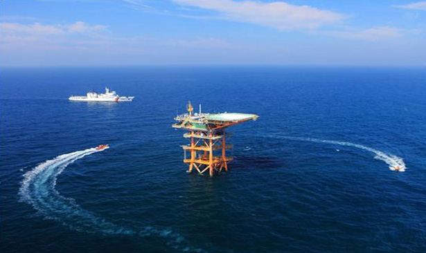
The Ieodo Ocean Research Station is a fixed facility for long-term observation through diverse equipments for comprehensive ocean research. It is unmanned and operates automatically. Employees and engineers of Korea Hydrographic and Oceanographic Agency regularly reside on Ieodo for over 50 days every year for research, facility operation and maintenance.
Because the Ieodo Ocean Resarch Station is installed in the open sea far away from the land, it can conduct a long-term monitoring of earthquakes, tsunamis, path prediction of storms, rise in the sea level from climate change, and changes in the marine environment. At the same time, it provides data on marine, climate, and environment to not only Korea but to the rest of the world. Furthermore, it plays a critical role of the advance base for exploring nearby continental shelf resources, and by providing real-time data necessary for military operation, marine leisure, and the marine industry, it displays its significant value in diverse areas related to the sea.
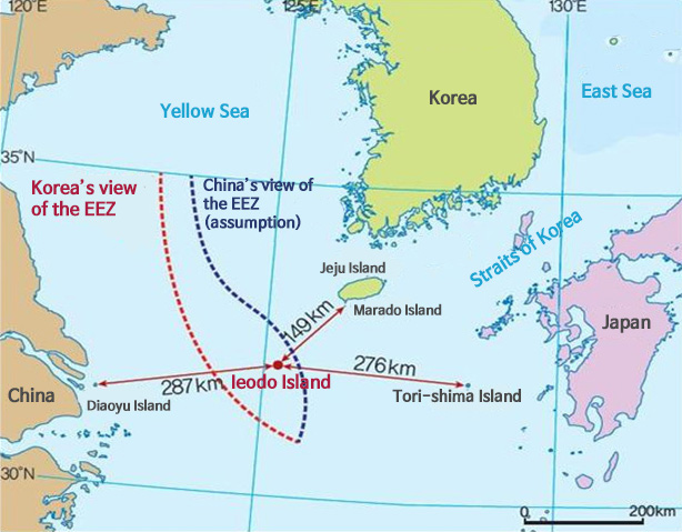
Korea and China argue that the waters where the Ieodo Ocean Research Station is located fall in the EEZ of respective countries. Then, what is the position of each country and how does Ieodo affect the EEZ of each country?
To resolve the issue of overlapping EEZs, Korea and China have been holding meetings to draw the sea boundary since 1996. As of November 2008, 14 meeting have been held but the two sides have yet to narrow their positions. Korea’s view is that the median line is the most equitable and realistic way to set the boundary between the two countries. On the other hand, China argues that the length of the coastline and the population in relevant regions need to be considered. Therefore, the boundary of EEZ as drawn by China lies closer to the western coast of Korea. Then, having said that, how does Iedo affect the current issue of overlapping EEZs? China holds a view that since Ieodo lies within the overlap in EEZs, Korea should not take unilateral action there. However, this can be regarded as China disregarding Korea’s actual dominance and occupation of Ieodo. To this, the Korean government has responded with an explicit position that the construction and use of the Ieodo Ocean Research Station on Ieodo, which is located closer to the Korean EEZ is based on the UNCLOS, and that there is not a problem.
The waters surrounding Ieodo have been continually managed by Korea with the declaration of the peace line in 1952 and the amendment of the Submarine Mineral Resources Development Act in 1970. If the sea boundary gets drawn based on the median line principle, Ieodo will fall in the Korean EEZ, so there is a need for continuous utilization and management.
※ The texts were written based on the outcome of “development of marine territory educational and promotional data” project pursued by the Korea Maritime Foundation in 2013.