
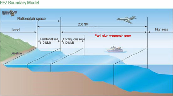
Like land and air space, coastal states have exclusive jurisdiction over marine territories. Such marine space can largely be divided into marine territories, contiguous zone, EEZ, ad continental shelves. Coastal states can control maritime safety and order with domestic law and when foreign ships cause problems in domestic waters, they can be arrested or punished on the grounds of domestic law. Furthermore, if a foreign ship disposes waste or elicits pollution in domestic waters, the country has the authority to regulate it and possesses exclusive right for maritime science investigation.
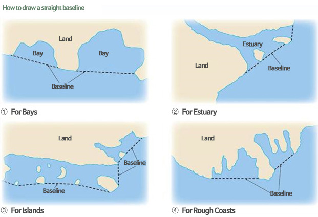
Although the principle is to set the coastline (normal baseline) at low tide as the standard baseline for territorial waters, when there are rough curves and many islands along the coastline, a straight baseline, which connects protruding points of islands acts as the baseline. In addition, archipelagic baseline applies in island states, which connects the most outward islands of the archipelago. Territorial waters are within 12 nautical miles of these baselines.
Baseline: The baseline is the line used as a standard in setting the boundary of territorial waters. It serves as the basis for not only territorial waters but also contiguous zones, EEZs, and continental shelves. Types of baselines are normal baselines, straight baselines, and archipelagic baselines.
Unlike territorial waters, countries are unabsle to exercise exclusive sovereignty over contiguous zones. However, as an area that continues for a certain range (max. 24 nautical miles from the baseline) from territorial waters, it can be set to ensure that the interests of a coastal state do not get violated. In contiguous zones, coastal states have the right to take measures such as monitoring of foreign ships regarding tariff, finance, management of entry and exit, health, and crime.
Contiguous zones originated from the Hovering Act, established in England in the 18th century. The Hovering Act was enacted with a purpose of monitoring foreign ships that engaged in smuggling while roaming the peripheries of England’s territorial waters, as an exception to the Principle of Freedom of the High Seas. Based on this Act, England, to effectively collect tariff, exercised authority over tariff controls within a certain range of waters nearby its territorial waters.
In the 18th century, in its early stage of independence, the US introduced a similar jurisdiction as that of England to limit smuggling and slavery. With many countries drawing their contiguous zones in the 19th century, such practice settled as customary law and eventually expanded the legal concept of contiguous zone in the early 20th century.
With the emergence of concepts like EEZ and continental shelves, the necessity of traditional contiguous zones is declining. If EEZs and continental shelves get dealt in light of jurisdiction, contiguous zones would be for the purpose of taking measures on tariff, management of entry and exit, and health.
Countries can draw their exclusive economic zones at as far as 200 nautical miles from their land. Once drawn, they have the exclusive right within this zone. Since EEZs are considered a territory besides the fact that the country cannot violate the freedom of other countries to sail, communicate, or use air space of this zone, each country controls EEZs with sovereignty.
EEZs are defined under the UNCLOS. In accordance with the UNCLOS, the territorial waters expanded from the previous 3 nautical miles to 12 nautical miles, and with the recognition of EEZs as far as 200 nautical miles, the area over which a country can exercise control over has significantly expanded from before. Eventually, more than one-third of the total area of seas has been included as EEZs.
When the distance between two countries does not satisfy 200 nautical miles of EEZs, interests between relevant countries conflict and there are many instances in which EEZs have yet to be clearly drawn. Korea, China, and Japan are such a case. It is difficult to set EEZs between these countries because the distance between them is relatively short. Since countries set EEZs to safeguard their interests, the possibility of conflict always exists. Therefore, the three countries are seeking ways to resolve the dispute through agreements.
※ The texts were written based on the outcome of “development of marine territory educational and promotional data” project pursued by the Korea Maritime Foundation in 2013.