
For a long time, the sea, unlike land, has been recognized as a common space that does not need to be divided into possessions. However, with gradual depletion of land resources and a rapid increase in demand for sea food, many countries began to recognize the sea with importance. Perhaps in reflection of this, the word “marine territory” is being used more frequently these days.
The sea holds the key to resolving numerous problems facing the humankind today. Naturally, the new maritime era in which the international community competes fiercely to secure marine territories has dawned. With more and more countries stepping up their efforts in advancing to the seas, the competition and conflict to gain more territories are deepening.
Consequently, there are efforts to maintain the maritime order through means such as adopting the UN Convention on the Law of the Sea (UNCLOS) in order to smoothly resolve disputes and prevent political and physical conflicts between countries that result from the competition for marine territories.
Marine territory can be narrowly defined as territorial waters, exclusive economic zones, and continental shelves under the jurisdiction of one country on which the country exercises sovereignty. However, it could also be defined more broadly beyond jurisdiction to include deep-sea areas where individual countries have secured the right to explore and develop, as well as Polar Regions where research bases are being operated.
Territory and Territorial Waters: They are basic elements constituting a country. Territory refers to land and islands that a country has sovereignty over, while territorial waters refer to the sea surrounding the territory.
The range of marine territory is decided based on an imaginary base line. The inner part from the base line is what we call domestic waters and to the outside are territorial waters, contiguous zone, exclusive economic zone, and continental shelves.
Territorial waters, which are governed by the same sovereignty as land, refer to area within 12 nautical miles from the baseline, and contiguous zone is from the baseline to as far as 24 nautical miles.
The Exclusive Economic Zone (EEZ), which has recently risen in importance with its infinite potential, can apply to a maximum distance of 200 nautical miles from the baseline.
Waters around the continental shelf can be set as 200 nautical miles if the natural extension is less than 200 nautical miles from the baseline, and a maximum of 350 nautical miles if more than 220 nautical miles.
※ Nautical mile: a unit of distance used in sailing and aviation. 1 nautical mile is equal to a minute of latitude on a chart, which is on average 1,852m.
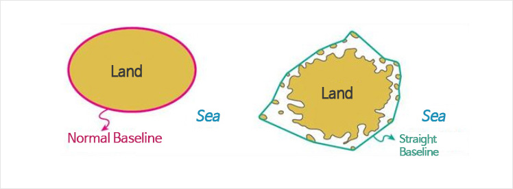
Baseline: Baseline can be distinguished as either a normal baseline or a straight baseline. The normal baseline applies to uneventful coastlines with the low water line set as the standard. On the other hand, a straight baseline applies to unstable coastlines with many islands, and is drawn by directly connecting the outermost islands.
※ The texts were written based on the outcome of “development of marine territory educational and promotional data” project pursued by the Korea Maritime Foundation in 2013.